
Category:Wikimedia projects and maps
Subcategories
This category has the following 18 subcategories, out of 18 total.
C
- Commons app map (30 F)
- Commons-coverage (tool) (1 F)
O
W
- Wiki Atlas (2 F)
- Wiki Explorer (2 F)
- Wikicaches (22 F)
- Wikidata geocoding (1 P, 156 F)
- WikiMap (5 F)
- Wikinity (4 F)
Pages in category "Wikimedia projects and maps"
The following 8 pages are in this category, out of 8 total.
Media in category "Wikimedia projects and maps"
The following 10 files are in this category, out of 10 total.
-
 ClaimMaps User Script.png 1,094 × 779; 82 KB
-
Create GeoJSON with JOSM and upload to Wikimedia Commons.webm 3 min 3 s, 640 × 360; 5.57 MB
-
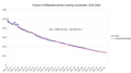 Fraction of Wikipedia articles missing coordinates, 2010-2024.png 2,006 × 1,112; 149 KB
-
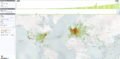
 GeoData.png 1,366 × 638; 62 KB
-
 Screenshot of Wikipedia IOS app.jpg 750 × 1,293; 103 KB
-
 Screenshot showing place type filter in Commons app's Nearby.jpg 1,080 × 2,400; 464 KB
-
 Unvisited trip map around Elm Street Historic District, New Haven CT.png 720 × 1,280; 717 KB
-
 Vizidata-screenshot.png 1,917 × 936; 1.63 MB
-
 Wikidata-gadget-overpass.png 505 × 548; 473 KB
-
 WikiMap Siemenshochhaus Erlangen.png 613 × 401; 287 KB


