File:"Hessenwege 9 und 11.jpg

Original file (3,264 × 2,448 pixels, file size: 6.44 MB, MIME type: image/jpeg)
Captions
Captions
Summary
[edit]Description"Hessenwege 9 und 11.jpg |
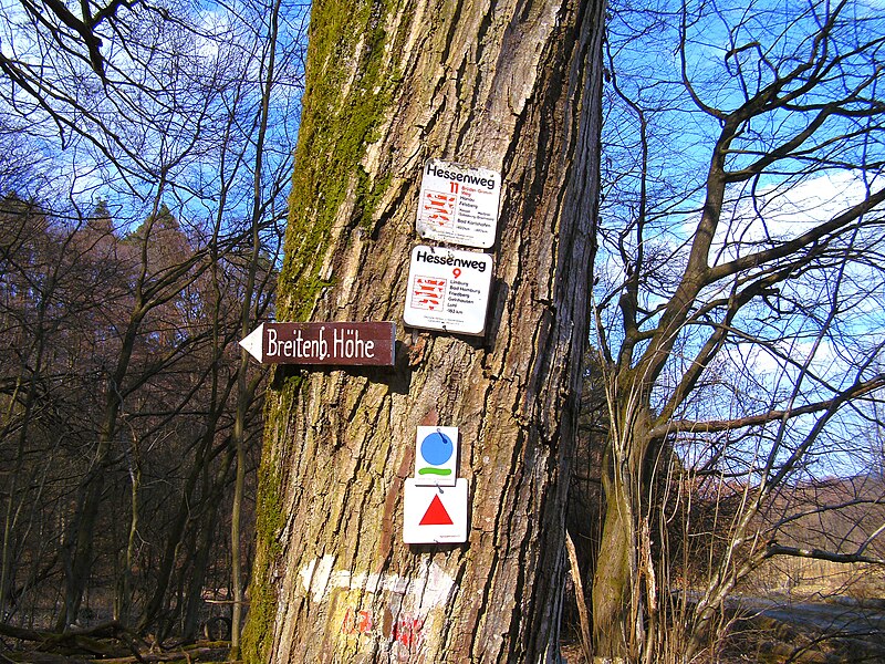
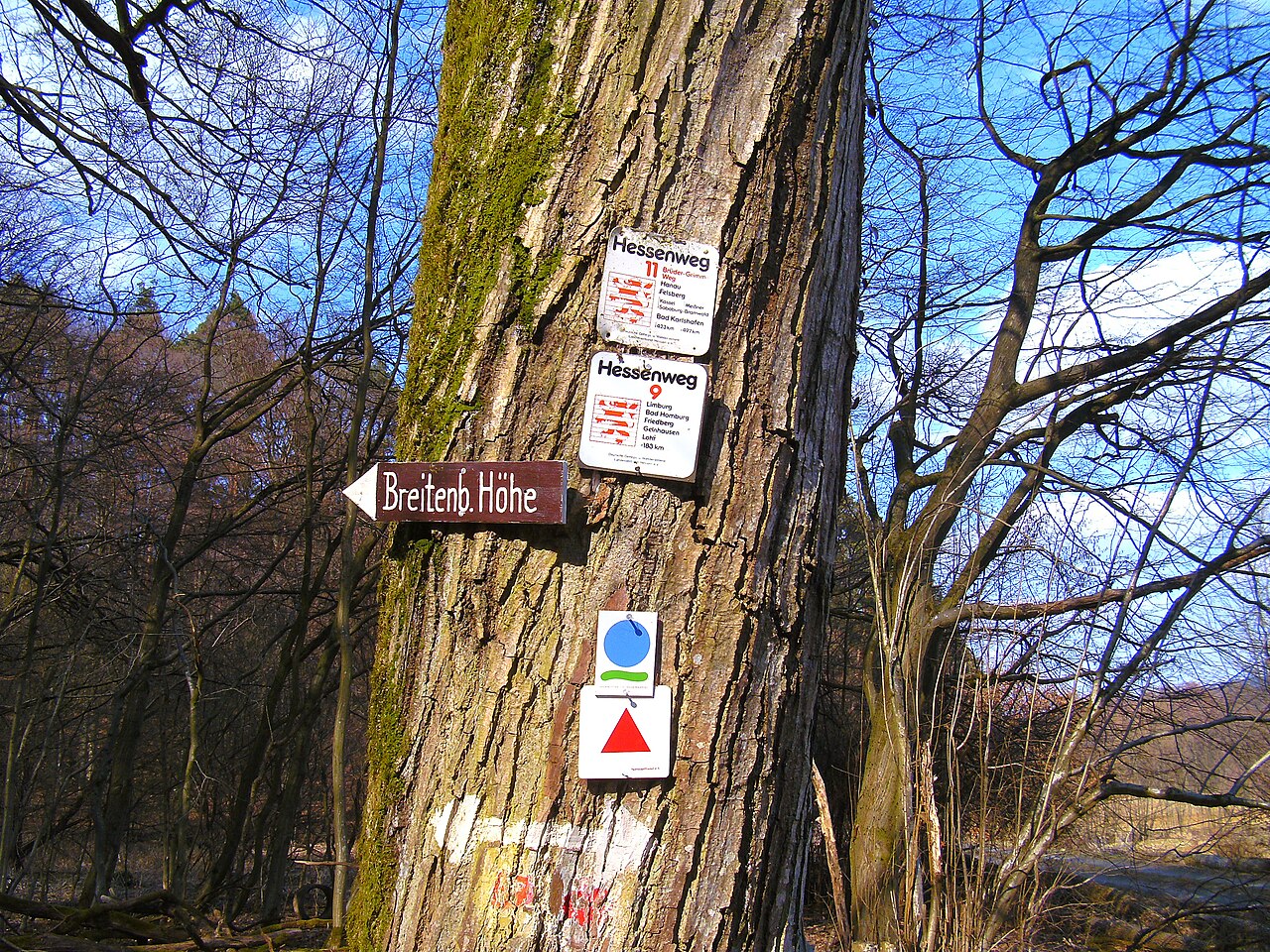
Deutsch: Altes Wanderwegsymbol der Hessenwege 9 und 11 im Bereich Biebergemünd.
|
|||
Date | ||||
Source | Own work | |||
Author | R.Raab | |||
Permission (Reusing this file) |
|
Camera location | 50° 10′ 06.52″ N, 9° 15′ 18.99″ E ![]() | View this and other nearby images on: OpenStreetMap | ![]() |
---|
Licensing
[edit]


- You are free:
- to share – to copy, distribute and transmit the work
- to remix – to adapt the work
- Under the following conditions:
- attribution – You must give appropriate credit, provide a link to the license, and indicate if changes were made. You may do so in any reasonable manner, but not in any way that suggests the licensor endorses you or your use.
- share alike – If you remix, transform, or build upon the material, you must distribute your contributions under the same or compatible license as the original.
File history
Click on a date/time to view the file as it appeared at that time.
Date/Time | Thumbnail | Dimensions | User | Comment | |
---|---|---|---|---|---|
current | 11:17, 22 January 2023 | ![]() | 3,264 × 2,448 (6.44 MB) | Surveyor54 (talk | contribs) | {{information |description={{de|1=Altes Wanderwegsymbol der Hessenwege 9 und 11 im Bereich Biebergemünd.}}{{On OSM |type=relation |OSM_ID=1076135}} |date=2013-04-07 |source={{own}} |author=R.Raab |permission={{User:Surveyor54/Lizenz/Ergaenzung 4.0}} |other versions= }} {{Location |1=50.168477 |2=9.255275}} == {{int:license-header}} == {{self|cc-by-sa-4.0}} Category:Hessenweg 9 |
You cannot overwrite this file.
File usage on Commons
The following page uses this file:
Metadata
This file contains additional information such as Exif metadata which may have been added by the digital camera, scanner, or software program used to create or digitize it. If the file has been modified from its original state, some details such as the timestamp may not fully reflect those of the original file. The timestamp is only as accurate as the clock in the camera, and it may be completely wrong.
Image title | |
---|---|
Camera manufacturer | Rollei |
Camera model | Rollei XS-8 |
Copyright holder | |
Exposure time | 1/297 sec (0.0033670033670034) |
F-number | f/4.7 |
ISO speed rating | 64 |
Date and time of data generation | 15:54, 7 April 2013 |
Lens focal length | 5.8 mm |
Latitude | 50° 10′ 6.52″ N |
Longitude | 9° 15′ 18.99″ E |
Altitude | 208.7 meters above sea level |
Orientation | Normal |
Horizontal resolution | 300 dpi |
Vertical resolution | 300 dpi |
Software used | darktable 4.2.0 |
File change date and time | 12:02, 22 January 2023 |
Y and C positioning | Co-sited |
Exposure Program | Normal program |
Exif version | 2.2 |
Date and time of digitizing | 15:54, 7 April 2013 |
Meaning of each component |
|
APEX shutter speed | 8.21 |
APEX aperture | 4.46 |
APEX exposure bias | 0 |
Maximum land aperture | 3.1 APEX (f/2.93) |
Metering mode | Multi-Spot |
Light source | Unknown |
Flash | Flash did not fire, compulsory flash suppression |
Supported Flashpix version | 1 |
Color space | sRGB |
Sensing method | One-chip color area sensor |
File source | Digital still camera |
Custom image processing | Custom process |
Exposure mode | Auto exposure |
White balance | Auto white balance |
Scene capture type | Standard |
Saturation | High saturation |
Sharpness | Hard |
GPS time (atomic clock) | 13:54 |
Speed unit | Kilometers per hour |
Speed of GPS receiver | 0.199604743083 |
GPS date | 7 April 2013 |
GPS tag version | 0.0.2.2 |
Rating (out of 5) | 1 |